Hurricane Irma is now a category 4 storm whose path has shifted from its west-southwest direction, to a western trail, according to the National Hurricane Center’s (N.H.C.) 5:00 p.m. advisory. The storm — with hurricane-force winds of near 130 miles per hour — is barreling towards the Leeward Islands, with hurricane watches and warnings being issued for well over a dozen islands by U.S., European and Caribbean authorities.
N.H.C., which issued hurricane watches for the USVI, Puerto Rico, Vieques and Culebra at 11:00 a.m. today, said the storm is expected to impact the Leeward Islands late Tuesday and into Wednesday morning.
Hurricane warnings were issued for 8 Caribbean islands, including Antigua and Barbuda, Montserrat, St. Kitts and Nevis, Anguilla, Saba, St. Eustatius, Saint Martin, and Saint Barthelemy.
A hurricane watch was issued for the British Virgin Islands by the government of Antigua; a hurricane watch was issued for the island of Dominica by the government of Barbados; and a hurricane watch was issued for Guadeloupe by the government of France.
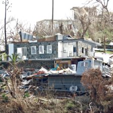
In a press conference held this afternoon at Government House on St. Croix, Governor Kenneth Mapp, flanked by some of his department and agency heads, said the Virgin Islands Government — from the Dept. of Health to the Virgin Islands Territorial Emergency Management Agency — is ready to respond to Hurricane Irma’s potentially damaging effects. (Watch video below.)
According to the N.H.C.’s 5:00 p.m. advisory, the center of Hurricane Irma was located near latitude 16.7 North, longitude 54.4 West. Irma is moving toward the west near 13 mph (20 km/h) and this general motion is expected to continue into Tuesday, followed by a turn toward the west-northwestward late Tuesday. On the forecast track, the center of Irma will move near or over portions of the northern Leeward Islands Tuesday night and early Wednesday.
Data from an Air Force Reserve Hurricane Hunter aircraft indicate that the maximum sustained winds have increased to near 130 mph (215 km/h) with higher gusts. Irma is a category 4 hurricane on the Saffir-Simpson Hurricane Wind Scale. Additional strengthening is forecast during the next 48 hours.
Hurricane-force winds extend outward up to 40 miles (65 km) from the center and tropical-storm-force winds extend outward up to 140 miles (220 km). The latest minimum central pressure reported by reconnaissance aircraft is 944 mb (27.88 inches).
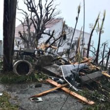
Storm Surge: The combination of a dangerous storm surge and large breaking waves will raise water levels by as much as 6 to 9 feet above normal tide levels along the coasts of the extreme northern Leeward Islands within the hurricane warning area near and to the north of the center of Irma. Near the coast, the surge will be accompanied by large and destructive waves.
The combination of a dangerous storm surge and the tide will cause normally dry areas near the coast to be flooded by rising waters moving inland from the shoreline. The water is expected to reach the following heights above ground if the peak surge occurs at the time of high tide.
The deepest water will occur along the immediate coast in areas of onshore winds, where the surge will be accompanied by large and destructive waves. Surge-related flooding depends on the relative timing of the surge and the tidal cycle, and can vary greatly over short distances. For information specific to your area, please see products issued by your local National Weather Service forecast office.
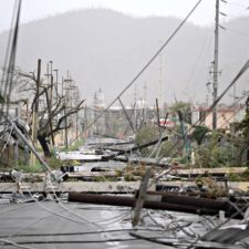
Wind: Hurricane conditions are expected within the hurricane warning area by Tuesday night, with tropical storm conditions expected by late Tuesday. Hurricane conditions are possible within the hurricane watch area in the Virgin Islands and Puerto Rico by late Wednesday, with tropical storm conditions possible by early Wednesday. Tropical Storm conditions are expected within the tropical storm warning area by late Tuesday.
Rainfall: Irma is expected to produce total rainfall accumulations of 3 to 6 inches across the Leeward Islands, with isolated maximum amounts of 10 inches across the northern Leeward Islands. These rainfall amounts may cause life-threatening flash floods and mudslides.
Surf: Swells generated by Irma will affect the northern Leeward Islands during the next several days. These swells are likely to cause life-threatening surf and rip current conditions. Please consult products from your local weather office.
Tags: category 4, hurricane irma
 Share On Facebook
 Tweet It